Pan-American Journey P6: Visiting Grand Canyon North and South Rim and Saying Goodbye to Arizona
Azadeh
Pan-American Journey P6: Visiting Grand Canyon North and South Rim and Saying Goodbye to Arizona
Posted on
We are back after more than a month to finally finish up our trip in Arizona. In the previous post we covered south of Arizona and ticked off few things on our car maintenance to do list and started to head north toward Grand Canyon.
Since we already have spent a lot of time in Flagstaff area, when we headed north again from Tucson, we took another road north and went through a big reservation area called Hopi Reservation which covers a big part of North Eastern Arizona.
The drive was beautiful on a straight empty road with the clouds which looked unreal. Soon we got to a intersection to choose between left and right. The left road was taking us to the South rim of the Grand Canyon and the right one to the north rim. We wanted to start with the south rim and then head to north rim before continuing north toward Utah.
The sun was setting when we finally could see a glimpse of the majestic Grand Canyon in the distance and we couldn’t believe what we were looking at. We were still out of the national park and tried to find a place to spend the night and enter the park early in the morning.
On the left side of the main road toward the national park entrance, there is a beautiful national forest called Kaibab covered by very short pine trees. We found a nice spot and called it home right next to the Grand Canyon.
Grand Canyon South Rim
mini canyons in the area
The next morning, we woke up early and headed straight to the entrance of the national park. It was our first national park which we entered from the proper gate and could buy the annual pass for all the national parks in the USA. We paid for our annual pass and got in.
This national park covers the south side of the Grand Canyon called the south rim and it is normally much busier then the northern side due to its distance to big cities like Flagstaff and Las Vegas. The main drive in the park follows the southern rim with nice big pullouts next to the points of interests and it only takes few minutes of walking to reach to each spot. By 10:00 am it was packed with people but because of the grand size of everything, it won’t bother much.
We’ve spent the whole day stopping at each point of interest and enjoyed differnet views. In the late afternoon when it got too hot, we headed back to our hidden camp spot in the forest to cool off and get ready for the next day.
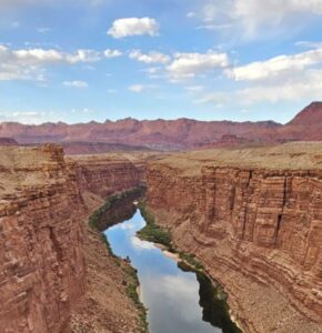
The plan for the next day was heading toward the north rim of the Grand Canyon which is a long way from the south rim. We had to follow the Grand Canyon on the opposite direction till we get to an iconic bridge on a very narrow part of the canyon.
It took us the whole day to reach the bridge and get to the other side of the canyon.
Before leaving I found a great spot next to the another canyon to stay for the night.
It’s always the same, we find the spot on the map, check the access and see if we can get there and have at least Plan B and Plan C, in case the spot that we picked wasn’t accessible and try to head there earlier in the afternoon if we have time. Sometimes it works and sometimes it doesn’t. That’s why we always have plan B and C, especially for more touristic area.
This one however worked for us and we camped right on the edge of an stunning canyon where the bald eagles were flying above our heads.
Bridge between north and south of the Grand Canyon
Another great camp in the Grand canyon region
The following morning, we woke up early and drove on the rough gravel road which leaded us to the edge of the canyon the day before and took some drone shots before heading to the north rim.
As soon as we took the dead-end road which leaded to the north rim of the Grand Canyon, to our surprise, the whole scenery changed. Both sides of the road were covered by lush green meadows and dense forests. There were still patches of snows under the trees and the weather was so much cooler than the day before on the south side.
We were pleasantly surprised with how beautiful was the north side of the Grand Canyon.
Don’t get me wrong, south side of the Canyon is stunning. I won’t forget the first time I saw the mighty Colorado river on the south side but it was also very very busy. North side on the other hand, was almost empty. It had a lot of trees which created an interesting contract with the warm red and yellow rock formations of the canyon. At the same time, made it much easier to take the longer hikes along the canyon in peace.
We have spent the whole day on the northern side of the national park and headed to the northern side of the Kaibab national forest before heading north to our last stop in Arizona!
The first Bison sign in the USA on the way to the North Rim
The Grand Canyon North Rim Views
The next stop on the way north was the Horseshoe Bend. An iconic spot which I always wanted to see in person since I saw it in an English book when I was a kid and learning English at School. It is a popular spot for tourists vising Grand Canyon too so it has a massive carpark next to the hike trailhead and even though, it is part of the Grand Canyon national park, they charge people an extra 5 dollars to park in the area. We got there around lunch time and it was already hot. An easy 30 minute walk, took us to the edge of the cliff and the stunning view of the horseshoe bend. We’ve sit on the edge and watched boats and canoes in the water deep down in the valley for a while before heading to Page to fill up our water tank, diesel tank and do some grocery shopping before heading toward Kanab, Utah.
Horseshoe Bend, Grand Canyon National Park, Arizona
In the next post, we start our trip in Utah. The state that I was most excited about and I can tell you this. It didn’t disappoint. Till then take care.